6 Great Hiking Trails with Beautiful Views in Maui, Hawaii (Maps included)
/Where to Hike and find Gorgeous Views in Maui, Hawaii
We’ve spent a lot of time on Maui at sea level, deep under the sea (see scuba), and at high elevations! Let’s be clear, I’m not the most outdoorsy experienced hiker, but I do love a nice hike and killer views! Try a coastal walk, hike to a waterfall or walk along a volcanic crater! Most of these hikes are free unless you are in a national park. Here are some hike suggestions for novice, intermediate, and experienced hikers!
See our shopping list (with some great budget-friendly dresses and tons of Hawaiian outfit ideas) straight from Amazon: Hawaii Packing Essentials
Haleakala Crater - Halemau’u Trail views
Haleakala Crater - Halemau’u Trail
1. Haleakala Crater - Halemau’u Trail
Address: Halemau'u Trailhead, Halemauu Trail, Kula, HI 96790
Follow Haleakala Highway east for 7.8 miles and turn left on 377 to continue on Haleakala Highway, which will travel south another 6 miles to a junction with Crater Road (378). Turn right and follow Crater Road 20.7 miles to the Haleakala Visitor Center.
The Hike: Haleakala offers a few hikes at various elevations. We opted for the Halemau’u Trail.
Haleakala National Park charges a fee to enter. Fees are $30 per vehicle or $25 per motorcycle. If you are entering on foot or bike the fee is $15 per person. You can also purchase a park-specific annual pass for $55. You need a reservation if you want to start before 7am because of the sunrise crowd.
Duration: The Halemau’u Trail is a 7+ mile hike at 3000 ft along the rim overlooking the summit basin. From the rim you can extend your hike taking the trail switchbacks down a thousand feet to wilderness grassland, then crosses a volcanic landscape of cinder cones and lava fields. I was 6 weeks pregnant and we did a shorter 2 mile hike along the rim that took us almost 2 hours.
What to pack: water, sunscreen, hat, sunglasses, rain gear (the weather can change very fast)
Pro tip: Plan the hike about 2 hours before sunset, so you can hike and then head up to the top of the summit to watch the sunset. Pack some sandwiches for dinner and then stargaze! You can see the Milky Way most nights!
Haleakala Crater - Halemau’u Trail Hike map
Waimoku Falls at the end of Pipiwai Trail
2. Road to Hana - Pipiwai Trail (Bamboo Forest)
Address: Kīpahulu Visitor Center, Hana, HI 96713 (Parking lot)
Haleakala National Park charges a fee to enter. Fees are $30 per vehicle or $25 per motorcycle. If you are entering on foot or bike the fee is $15 per person. You can also purchase a park-specific annual pass for $55.
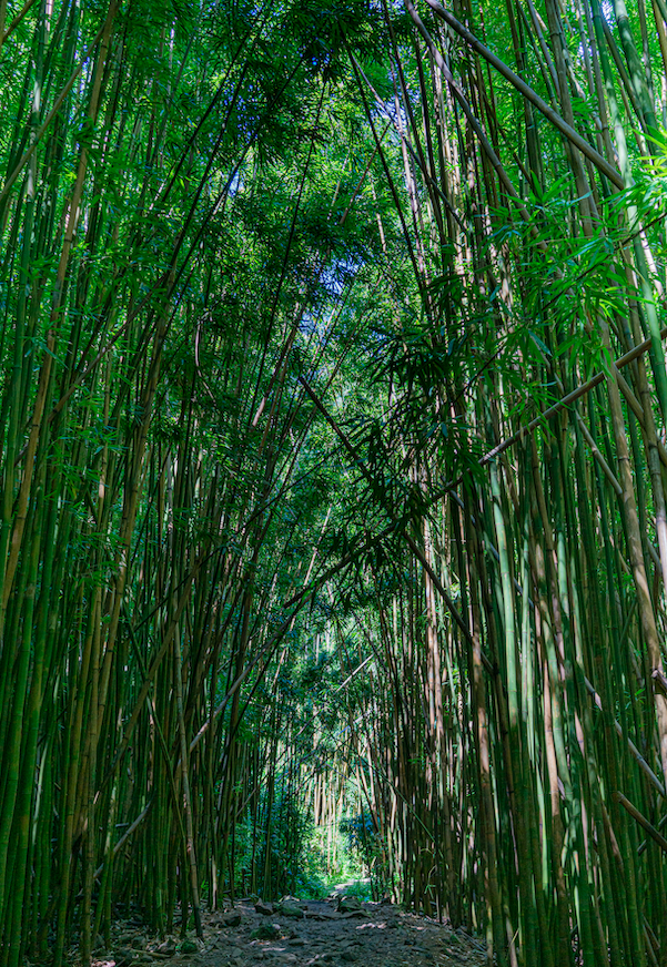
The Hike: We’ve done this hike quite a few times and it never disappoints! You’ll find this near the end of the Road to Hana in Haleakala park. First you’ll hike on a trail through the trees (around the big banyan tree), then through a bamboo forest, and you’ll end up at Waimouku Falls!
Difficulty: Fairly easy - lots of families on this trail. It can get muddy in spots so wear proper shoes and watch where you step!
Duration: It’s about 4 miles round trip and takes at least 2 hours. The elevation is about 650 ft and the trail is moderately easy.
What to pack: water, sunscreen, hat, sunglasses, snacks, towel and swimsuit if you want to dip in the waterfall or ‘Ohe’o Gulch
Check out what else you can do on the Road to Hana
Pipiwai Trail - Bamboo Forest - Road to Hana - Maui
3. Wailea Trail - Hoapili Trail
Address: 8650 Must Hold Block Boundary, Kihei, HI 96753
The Hike: After you pass the fancy resorts in Wailea, if you continue down Makena road, it dead ends with a nice hiking trail along the water. Sometimes you can see dolphins early in the morning - look at the wakes of the boats! We were lucky enough to find a Hawaiian Monk Seal that had just given birth days prior and was on the shore with her pup. This hike begins at La Pérouse Bay. We took the Hoapili Trail to the Hanomanioa Light House where at the end of the trail is one of those natural pools that you often see influencers float in on Instagram. If you’re lucky, you’ll come across some black mountain goats along the way! There are also great little spots along the beach to stop and have a small private beach area all to yourself!
Difficulty: Moderate - the first mile is easy and shaded along the beach. The lava field can be a little slippery with loose lava gravel and is in full sun.
Duration: To get to the lighthouse and natural pool it’s about 3 miles.
What to Pack: water, sunscreen, hat, sunglasses (the trail is shaded at first, but the lava fields are in full sun), towel and swimsuit
See our shopping list (with some great budget-friendly dresses and tons of Hawaiian outfit ideas) straight from Amazon: Hawaii Packing Essentials
Wailea Natural Pool - Hoapili Trail
Kapalua Coastal Trail
4. Kapalua Coastal Walking Trail
Address: 99 Coconut Grove Ln, Lahaina, HI 96761
The Hike: Looking for an easy stroll along the beach with fantastic views? This is your trail! This path is pretty much paved the entire way and a great coastal walk if you’re not in the mood to walk in the sand. We parked near Merriman’s in the public parking lot. Get there early for a spot or park along the street.
Difficulty: Easy! Great for families, a lot of it is paved.
Duration: Per my Apple Watch, we walked 37 mins for 1.57 miles from the parking lot to Oneloa Bay and back.
What to Pack: Flips flops or tennis shoes (shoes are better for your feet), water, sunscreen, hat, sunglasses
See our shopping list (with some great budget-friendly dresses and tons of Hawaiian outfit ideas) straight from Amazon: Hawaii Packing Essentials
Kapalua Coastal Trail Map
Iao Needle in Iao Valley
5. Iao Valley Hidden Trail
Address: 54 S High St, Wailuku, HI 96793
Hours: Daily, 7:00 AM - 6:00 PM
Parking Prices: Non-Commercial Vehicles
Residents = No Charge w/ID or DL
Non-Residents = $10
Entrance fee - $5 for non-residents
The Hike: This hike is fun through the jungle and shaded almost the entire way.
If you’re looking for a very short hike, there is a paved trail to the Iao Needle viewpoint. There is a lookout with a gazebo to hike to that has some benches with views of the needle. It was an easy hike, only .6 miles, 200 ft in elevation, and a quick 10-minute walk from the parking lot.
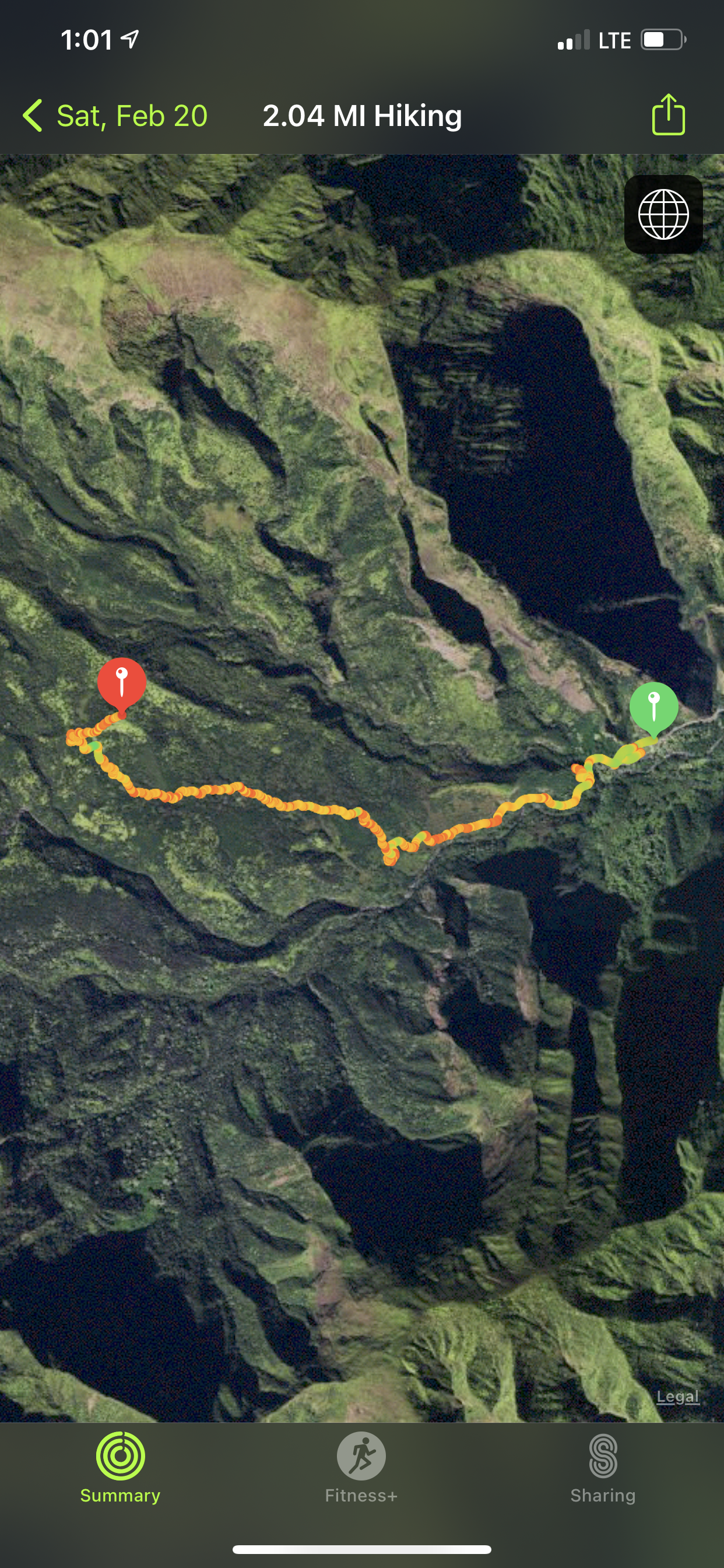
There is a trail behind the gazebo, but there are signs to not pass the barriers. This trail is dangerous and should be avoided. However, if you head down to the stream and hike up the mountains you’ll end up on the same trail just past the steep dangerous part. See the screenshot map below.
Difficulty: Fairly easy - it was nice and cool under the trees! There is a steep incline the last quarter mile but otherwise it was pretty smooth. There was some mud because there is often rain on this part of the island.
Duration: I did this hike at 6 weeks pregnant! We took it a little slower so it took us an hour and 45 mins to get to the top of the lookout which was about 2 miles and an elevation gain of 1061 feet. It was a little muddy at times so be careful! The trail doesn’t have any markers, but the path is pretty well-traveled so just stay on that which will take you to the top.
What to pack: Water, snacks, and a towel/swimsuit if you want to jump in the stream
See more in our post: Exploring Iao Valley
Iao Valley Secret Trail Map
Views from Waihee Ridge Hiking Trail
6. Waihee Ridge Hiking Trail
Address: Kahekili Hwy, Wailuku, HI 96793
Directions: Drive along the north shore to the trailhead. Parking is free but get there early for a good spot. There are Porta potties in the parking lot.
The Hike: The hike is in mainly in the sun along a mountain ridge. The view stays pretty much the same as you hike up, you are just higher in elevation.
Difficulty: Moderate - there is a pretty steep incline in some spots. We took a few breaks on our way up.
Duration: It was a nice sunny hike that took us about 2 hours round trip, over 2 miles, and almost 1500 ft in elevation per my Apple Watch.
What to pack: water, sunscreen, hat, sunglasses, snacks, towel
If you liked this post please share it on your favorite social media site using the Share button below because we’d love to get the word out! Feel free to pin this to your favorite Pinterest board:


Planning a trip to Maui? This Ultimate Maui Travel Guide (2026) covers everything you need to know—from where to stay and the best time to visit, to top things to do, restaurants, and real insider tips. Whether you’re traveling with kids, planning a honeymoon or babymoon, or visiting Maui for the first time, this guide breaks down Kāʻanapali vs. Wailea, must-see attractions, itineraries, and planning advice to help you create the perfect Maui vacation.Planning a trip to Maui? This Ultimate Maui Travel Guide (2026) covers everything you need to know—from where to stay and the best time to visit, to top things to do, restaurants, and real insider tips. Whether you’re traveling with kids, planning a honeymoon or babymoon, or visiting Maui for the first time, this guide breaks down Kāʻanapali vs. Wailea, must-see attractions, itineraries, and planning advice to help you create the perfect Maui vacation.